Disclaimer: The Physical Oceanography Research Group (PO-Res. Grp) makes every
effort to ensure that information contained in these pages is accurate and up to
date. However, the PO-Res. Grp accepts no liability and/or responsibility for the
reliance placed by the users of these pages on the information contained in these
pages or any other information accessed via this web page. The information provided
in these pages is provided on an "as is" basis and no warranties of any kind are
issued whether expressly or implied by the PO-Res. Grp on the information provided.
Tsunami waves hit Malta
1st November 2018
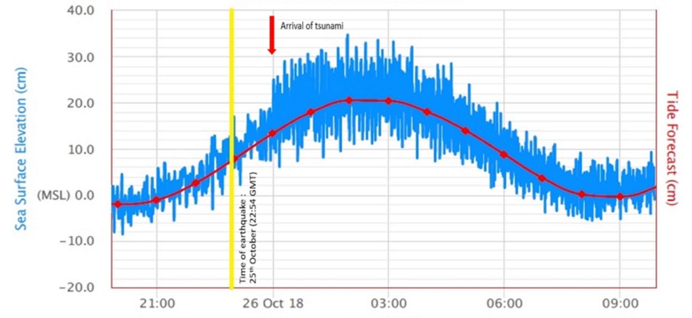
Trace of the sea level oscillations registered by the station at Portomaso
marina
The Department of Geosciences has been actively looking at seismic and sea level
data from its monitoring stations to decipher any local impacts from the earthquake
triggered in the open sea on Thursday 25 October at 22:54 UTC, west of Greece
(37.49°N; 20.6°E) some 580 km away from the Maltese Islands.
Tectonic activities of this kind can give rise to rapid displacements in the sea
bed and consequently to vertical shifts in the water column leading to disturbances
that travel away from the source at more than 700 km per hour (the typical speed
of a commercial jet), depending on the depth of the sea, and reducing their speed
by a factor of 4.5 as they cross the Malta Escarpment on to the much shallower
continental shelf area. Upon reaching shallower water areas, these waves gain in
amplitude and manifest as a tsunami with often very devastating outcomes on the
coast. The eastern coast of Malta is particularly vulnerable to tsunami waves
originating from earthquake epicentres near Greece, and traversing all the way
across the deep Ionian Sea to reach our islands in just about an hour.
The figure shows an extract from the sea level data collected by a gauge positioned
inside the Portomaso Marina in St Julian's. The station is maintained by the Physical
Oceanography Research Group and has been operating with real time transmission of
data for the last 17 years. It samples sea level measurements every 15s thus
permitting the well known seiches, known as the 'milgħuba', to be monitored in
detail. These seiches are related to atmospheric disturbances and have nothing
to do with tsunami; they are a resonance response of the marina water body to open
sea long period waves triggered by atmospheric gravity waves.
Tsunami-related oscillations have the same typical frequencies as those of the
seiches, which therefore camouflage tsunami signals, rendering detection very difficult
except in the case of extraordinarily strong events. In the particular case of this
earthquake event, the tsunami signal manifested as an intensification of the marina
oscillations starting from midnight of 26 October, when the tsunami waves reached
the Maltese Islands giving rise to a superimposed effect on the already existing
seiches. This led to very modest sea level vertical excursions of the order of 25cm,
and sea level movements occurring in repeated short cycles of the order of minutes.
Luckily not a big deal this time, and a weak tsunami without consequences! But Prof.
Aldo Drago mentions that 'these apparently insignificant events are important since
they present real case situations and provide typical datasets that we can use to
experiment on how to best automate the detection of tsunami signals against the
background seiches [...] not a mean challenge at all.'
This study will contribute to the Italia-Malta project SIMIT-THARSY, during which
the University of Malta will be strengthening its earthquake and tsunami monitoring
capabilities through seismographic and sea level gauge instrumentation and software,
evaluating tsunami scenarios, and providing input to the Civil Protection department.
Meanwhile aftershocks of the earthquake, some with magnitude greater than 5.0,
continue to occur even one week later, and are being monitored by the Seismic
Monitoring and Research Group.