Disclaimer: The Physical Oceanography Research Group (PO-Res. Grp) makes every
effort to ensure that information contained in these pages is accurate and up to
date. However, the PO-Res. Grp accepts no liability and/or responsibility for the
reliance placed by the users of these pages on the information contained in these
pages or any other information accessed via this web page. The information provided
in these pages is provided on an "as is" basis and no warranties of any kind are
issued whether expressly or implied by the PO-Res. Grp on the information provided.
Malta shelf area battles high waves
16th December 2019
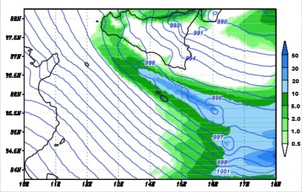
Precipitation (in mm over 3h) predicted for
1am (local time) on 14 December 2019 in the Central Mediterranean. Isolines
show curves joining points of equal atmospheric pressure in millibars.
Data produced by the MARIA/eta model run by the Physical Oceanography Research
Group, Dept. of Geosciences, University of Malta
The meteo-marine conditions in the sea domain around the Maltese Islands and the
Malta-Sicily Channel experienced in the night between Friday 13th and Saturday
14th December were amongst the strongest triggered by recent storms. A depression
on the Adriatic Sea produced a steep atmospheric pressure gradient over the Central
Mediterranean leading to north-westerly gale winds reaching up to 22 m s-1 (about
50 mph) in the open sea areas close to Malta and Sicily on Saturday morning. These
extreme conditions were predicted and assessed by numerical atmospheric and wave
models which verified the evolution of the storm, accompanied by torrential rain
especially in the sea north of Malta, and by very high waves reaching a significant
wave height of 7m west of Gozo where the exposure to Mistral wind is conspicuous.
Such extreme wind and wave conditions are known to have a return period of the order
of 10 years. These very adverse conditions started to attenuate on Saturday afternoon
when the depression moved on to the Aegean.
The Physical Oceanography Research Group (PO.Res.Grp) specialises in the operational
running of several numerical models that simulate and make predictions of atmospheric
conditions and sea states. These models provide detailed spatial and temporal information
in the form of maps showing how meteo-marine essential parameters like wind, precipitation,
air and sea surface temperature, sea currents and waves are changing. This service is
provided in real time from a dedicated portal (www.capemalta.net) to many national
stakeholders that need such data for their operations, and to general users by means
of a smartphone app called KAPTAN. While other meteo services provide average conditions
for a domain covering for example the whole Maltese Islands and the coastal sea areas,
the service offered by the PO.Res.Grp gives spatial details of how these conditions
change from place to place in the approaches to Malta and Gozo, and in the stretches
of sea beyond. Several of these models have been upgraded or developed under the
CALYPSO series of projects, the most recent project being CALYPSO South which is
partially funded under the Interreg V-A Italia-Malta programme 2014-2020.
The damages reported on land were considerable, but what was witnessed on land
cannot be in any way compared to the force and vehemence experienced at sea. Luckily
the western coast was hit this time, with waves exhausting their energy against the
high standing cliffs and this relatively uninhabitated stretch of coast of Malta
and Gozo, otherwise the consequences would have been much worse.
Precipitation (in mm over 3h) predicted for 1am (local time) on 14th December
2019 in the Central Mediterranean. Isolines show curves joining points of equal
atmospheric pressure in millibars. Data produced by the MARIA/eta model run by
the Physical Oceanography Research Group, Dept. of Geosciences, University of Malta.
Sea wave heights higher than 7m west of the
Maltese Islands and in the Malta-Sicily Channel. Simulations by the
ROSARIO-SWAN numerical model run by the Physical Oceanography Research
Group, Dept. of Geosciences, University of Malta for the morning of 14
December 2019