Disclaimer: The Physical Oceanography Research Group (PO-Res. Grp) makes every
effort to ensure that information contained in these pages is accurate and up to
date. However, the PO-Res. Grp accepts no liability and/or responsibility for the
reliance placed by the users of these pages on the information contained in these
pages or any other information accessed via this web page. The information provided
in these pages is provided on an "as is" basis and no warranties of any kind are
issued whether expressly or implied by the PO-Res. Grp on the information provided.
First sea level measurements on the southern coast of Malta
19th October 2019
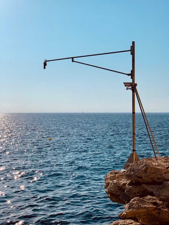
The Cirkewwa IDSL station monitors sea level
fluctuations by a microwave sensor mounted above the sea surface, measuring
the distance of the air gap between the sensor and the sea
We are not safe! Past events are evidence that the Mediterranean Sea is not spared
from large tsunamis, and the Maltese Islands can face such seismic-generated,
devastating sea waves especially from its eastern approaches. Severe wind and
adverse weather conditions are often accompanied by deep lows in atmospheric
pressure to which the sea responds with a rise in level (storm surge) providing
like a barrier wall to storm water flow into the sea, leading to flooding like
that we often experience in Msida. Flooding of coastal areas can however also
occur when it is least expected during calm weather due to a phenomenon known as
the ‘Milgħuba’, often referred to as a meteo tsunami, consisting of large and
rapid sea level fluctuations occurring over a span of a few minutes and triggered
in such cases by atmospheric gravity waves. Besides these transient phenomena sea
level monitoring is also important to assess climatic changes, but with a firm
commitment to long term data acquisition.
It is therefore not surprising that the history of the PO-Unit, now the Physical
Oceanography Research Group (PO.Res.Grp), indeed started in 26 years ago, more
precisely in May 1993, with a sea level gauge installed in Mellieha Bay, the first
digital sea sensor measuring sea level fluctuations at an unprecedented frequency
of 30 records every hour and permitting the sea level variability in the Maltese
Islands to be assessed with precision and long term datasets. In 2001, a new more
sophisticated sea level gauge was set up in Portomaso where it still continues to
transmit valuable data in real time (meteo-marine observations on
www.capemalta.net).
A new gauge has recently been added, at a station within the premises of Paradise
Bay Resort at Cirkewwa, to measure sea level variability for the first time on the
southern coast of Malta. The position of the Maltese Islands at the edge of the
continental shelf that connects the archipelago to the Sicilian mainland presents
an ideal oceanographic case, mimicking a permanent research vessel, to study some
still unresolved dynamical features pertaining to this sea domain, like shelf
oscillations and topographically trapped waves that both produce a significant
signature on the sea surface movements.
This installation matured from a collaboration between the Joint Research Centre
of the European Commission (JRC) and the PO.Res.Grp with the coordination of Prof.
Aldo Drago who leads sea level assessments at the University of Malta. Dr Adam
Gauci is the lead responsible for the observing system of the PO.Res.Grp within
the Department of Geosciences, and executed the installation of the new gauge
with the support of Dr. Alessandro Annunziato from JRC-Ispra. The measuring device
consists of an Inexpensive Device for Sea Level (IDSL) mounted above the sea,
measuring the distance of the air gap from the sea by means of a microwave sensor.
Data logging is made by a Raspberry Pi computer with a sampling interval is 15 s,
and data transmission by GSM every minute to a server where it is stored, quality
controlled, and prepared for online visualisation. The station is powered by a
solar panel, and batteries that can provide an autonomy of seven days.
Like the station in Portomaso, this new station forms part of the Tsunami Warning
and Mitigation System (NEAMTWS) established under the Inter-Governmental Oceanographic
Commission (IOC) of UNESCO. This effort is being soon extended by a third station
in Marsaxlokk, increasing the number of real time stations maintained by the PO.Res.Grp
to a total of three. This sea level network is a building block for the national
tsunami alert system that the Civil Protection Department is planning to deploy.