Disclaimer: The Physical Oceanography Research Group (PO-Res. Grp) makes every
effort to ensure that information contained in these pages is accurate and up to
date. However, the PO-Res. Grp accepts no liability and/or responsibility for the
reliance placed by the users of these pages on the information contained in these
pages or any other information accessed via this web page. The information provided
in these pages is provided on an "as is" basis and no warranties of any kind are
issued whether expressly or implied by the PO-Res. Grp on the information provided.
CALYPSO HF radar network featured in Remote Sensing of Environment
5th March 2019
The focus of the work is the validation of HF radar observations using comparisons
with in situ measurements. Data is provided from twenty-two surface drifters deployed
in four batches over a period of one year, and near-surface current profiles acquired
by a vessel-mounted Acoustic Doppler Current Profiler station (ADCP) at six selected
locations. The analysis comprises radar site-to-site baseline analyses, providing
quantitative assessments on the accuracy of the HF radar total velocity fields.
External radio-frequency interferences lead to significant gaps in the HFR coverage,
which were minimised by an interpolation technique applied to the surface current
fields. The validation of HFR velocities was first performed for each individual
station in the network, using data generated with both the ideal and the measured
antenna patterns. The validation was then repeated with pairs of HFR stations
using the site-to-site baseline error analysis. The analysis confirms that the
baseline error estimations and the full validation metrics for this HFR frequency
band are consistent, and in some aspects superior, when compared to results from
similar studies in other regions.
This work was partially funded by the CALYPSO series of Italia-Malta Interreg V-A
projects comprising a consortium of Maltese and Sicilian partners led by the
Physical Oceanography Research Group of the Dept. of Geosciences at the University
of Malta.
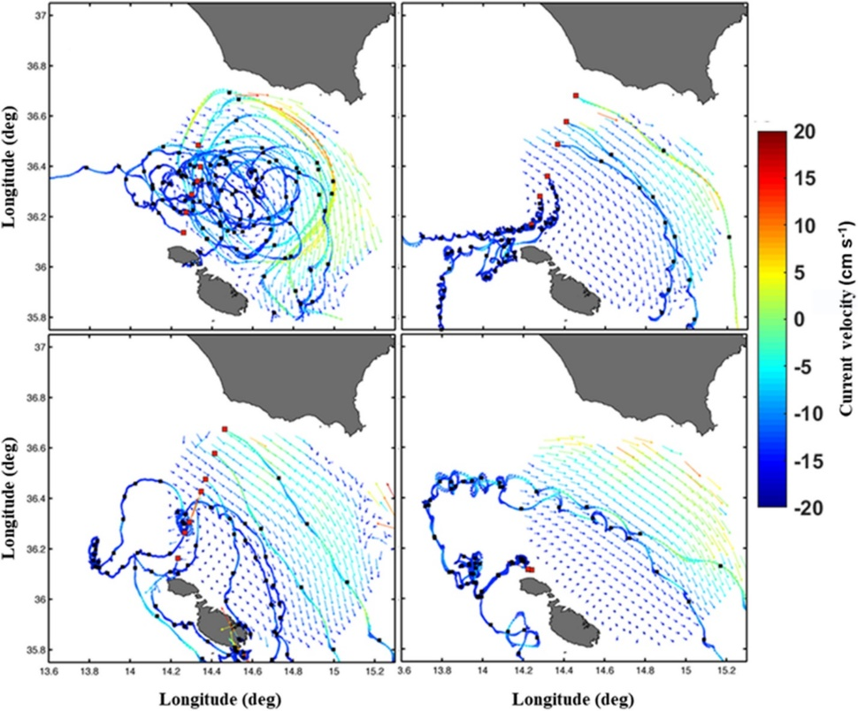
Locations (red squares) of the drifter deployment locations, trajectories
colour-coded with their speeds (units cm s−1), and positions (black squares)
at 24-h time intervals, and the corresponding time-averaged radar surface
current field.
Time averages are computed for the periods during which drifters were within
the radar domain for each deployment (December 2012, upper left panel;
June 2013, upper right panel; September 2013, lower left panel; October
2013, lower right panel).